")


VSDC
Store
Templates / Telemetry Widgets / Tech Dash
VSDC Tech Dash
25 templates
$49
BuyDescription
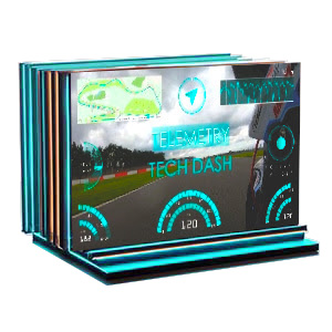
Create professional movie-style HUD interfaces with Tech Dash! This pack delivers authentic OCR A Extended telemetry widgets featuring real-time Speed Arcs, G-Force meters and more.
Get instant results with pre-designed color-coordinated gauge suites and transform your tech reviews, gaming content, GoPro videos and sci-fi projects with cinematic data displays!
Get instant results with pre-designed color-coordinated gauge suites and transform your tech reviews, gaming content, GoPro videos and sci-fi projects with cinematic data displays!
Key Features
SVG Vector Graphics
Full Customization
Color Presets
Individual Widgets & Full Suites
Number Of Items: 25
Frequently Asked Questions
How do I add a map and speedometer to my motorcycle vlog?
It's a one-click process! Just import your GoPro or Insta360 footage into VSDC. VSDC Video Editor will automatically detect the GPS data embedded in your video file and you will be able to add a stylish map of your route, along with a real-time speedometer, altitude graph and more. You don't need to manually track your route or keyframe the speed because it's all done for you, so you can focus on the ride and the storytelling.
It's a one-click process! Just import your GoPro or Insta360 footage into VSDC. VSDC Video Editor will automatically detect the GPS data embedded in your video file and you will be able to add a stylish map of your route, along with a real-time speedometer, altitude graph and more. You don't need to manually track your route or keyframe the speed because it's all done for you, so you can focus on the ride and the storytelling.
I'm an adventure travel vlogger. Can I use this pack to show my hiking elevation or off-road trips?
Absolutely. This is a perfect pack for showcasing your adventures. Here you’ll find great options to display altitude, speed, elevation gain throughout your hike, bike trail or 4x4 journey. You can create a compelling visual story that shows not just where you went, but also, for example, how challenging the terrain was, making your content much more immersive.
Absolutely. This is a perfect pack for showcasing your adventures. Here you’ll find great options to display altitude, speed, elevation gain throughout your hike, bike trail or 4x4 journey. You can create a compelling visual story that shows not just where you went, but also, for example, how challenging the terrain was, making your content much more immersive.
My road trip footage feels flat. How can these widgets make my USA travel vlogs more cinematic?
They can help you transform hours of highway footage into a dynamic, data-driven story. Instead of just telling your viewers you're driving, for instance, through Monument Valley, the "Tech Dash" overlays can show them your exact speed, heading (direction) and GPS coordinates on a sleek, futuristic map. This adds a layer of authenticity and a high-tech, "mission control" feel that is highly popular on platforms like YouTube.
They can help you transform hours of highway footage into a dynamic, data-driven story. Instead of just telling your viewers you're driving, for instance, through Monument Valley, the "Tech Dash" overlays can show them your exact speed, heading (direction) and GPS coordinates on a sleek, futuristic map. This adds a layer of authenticity and a high-tech, "mission control" feel that is highly popular on platforms like YouTube.
Watch us on YouTube
 / @VSDCFreeVideoEditor
© 2011-2026, www.videosoftdev.com, FLASH-INTEGRO LLC. Política de privacidade | Termos de uso | Sobre nós
Todas as marcas comerciais mencionadas neste documento são de propriedade exclusiva de seus respectivos proprietários.
A cópia de qualquer material deste site é permitida apenas com o consentimento por escrito da Administração do Site.